Coordinate_system
Data Structure: Coordinate_system |
|
Description |
Local coordinate system |
Usage |
Coordinate_system NUM=ival where ival is the data structure number |
Description |
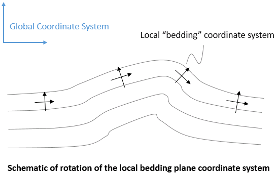
Overview The Coordinate_system data structure defines local coordinate systems via direction cosine matrices. Each local coordinate system may be assigned to one or more geometry entities using Transformed_freedoms. This may be desirable for example to apply normal displacements to tilted boundaries. Coordinate systems may be assigned a bedding Reference_orientation so the local coordinate systems rotate with the stratigraphy unit bedding plane. This may be useful for example to define fracture systems parallel to the bedding (e.g. allow bedding plane slip).
Notes •Several different Coordinate_system data structures may be specified. •The local coordinate system may be defined via either the Direction_cosines or by specifying the location of three points that define the origin ( Coordinates_origin), the direction of the local x-axis ( Coordinates_x_axis) and the local xy-plane ( Coordinates_xy_plane).
Examples demonstrating the usage of Coordinate_system include: •matp_2d4n_005c •matp_3d8n_005f |
| Name Name of coordinate system |
Usage |
||||
|
||||
Description |
||||
Name of coordinate system.
|
| Cylindrical_axis_points Points describing the axis of the cylindrical coordinate system |
Usage |
|||||||||||||||
|
|||||||||||||||
Description |
|||||||||||||||
Points describing the axis of the cylindrical coordinate system
|
|||||||||||||||
| Cylindrical_axis Vector describing the axis of the cylindrical coordinate system |
Usage |
|||||||||||||||
|
|||||||||||||||
Description |
|||||||||||||||
Vector describing the axis of the cylindrical coordinate system
|
|||||||||||||||
| Direction_cosines Direction cosines for coordinate system |
Usage |
|||||||||||||||
|
|||||||||||||||
Description |
|||||||||||||||
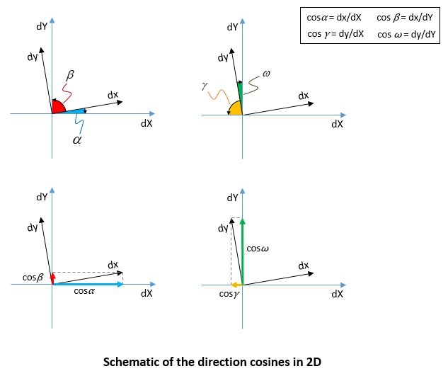
Direction cosines for coordinate system. The direction cosines are defined in 2-D as a 2x2 Matrix: •Input values dx/dX, dx/dY - local x-axis dy/dX, dy/dY - local y-axis
The direction cosines are defined in 3-D as: •Input values dx/dX, dx/dY, dx/dZ - local x-axis dy/dX, dy/dY, dy/dZ - local y-axis dz/dX, dz/dY, dz/dZ - local z-axis
|
|||||||||||||||
| Coordinates_origin Coordinates of origin of the coordinate system |
Usage |
|||||||||||||||
|
|||||||||||||||
Description |
|||||||||||||||
Coordinates of origin of the coordinate system.
|
|||||||||||||||
| Coordinates_x_axis Coordinates of point defining the local x-axis |
Usage |
|||||||||||||||
|
|||||||||||||||
Description |
|||||||||||||||
Coordinates of point defining the local x-axis.
|
|||||||||||||||
| Coordinates_xy_plane Coordinates of point defining the local xy-plane in 3-D |
Usage |
|||||||||||||||
|
|||||||||||||||
Description |
|||||||||||||||
Coordinates of point defining the local xy-plane in 3-D (not required in 2-D). The local xy-plane is created to contain the local x-axis and this point.
|
|||||||||||||||
| Reference_orientation Type of orientation for the coordinate system |
Usage |
||||
|
||||
Description |
||||
Defines the type of orientation for the coordinate system. Valid options are: • "Global" - Orientation is defined relative to the global system (default) • "Bedding" - Orientation is defined relative to the approximate bedding plane system
Notes •Stratigraphy must be defined in order to use the "Bedding" reference orientations.
|


