Util_create_stratigraphy
Data Structure: Util_create_stratigraphy |
|
Description |
Create stratigraphy and horizons using group data |
Usage |
Util_create_stratigraphy NUM=ival where ival is the data structure number |
Description |
Overview The Util_create_stratigraphy data structure can be used to specify that stratigraphy should be constructed using the group data. The stratigraphy is comprised of two parts:
•Stratigraphy Units i.e. the group of surfaces (2-D) or volumes (3-D) that define the geometry of the stratigraphy unit. •Stratigraphy horizons i.e. the lines (2-D) or surfaces (3-D) that define the top horizon of the stratigraphy unit.
Notes •The list of stratigraphy units must be defined in depositional order, from oldest (bottom) to youngest (top). •The stratigraphy horizons are automatically evaluated using the shared surfaces of the current and overlying horizon.
|
| Units List of unit names (Compulsory) |
Usage |
|||||||||||||||
|
|||||||||||||||
Description |
|||||||||||||||
Units or alternatively Unit_names defines a list of stratigraphy unit names in deposition order starting from the base of the model.
|
|||||||||||||||
| Top_horizon_tolerance Tolerance angle for identification of top surface horizon |
Usage |
||||
|
||||
Description |
||||
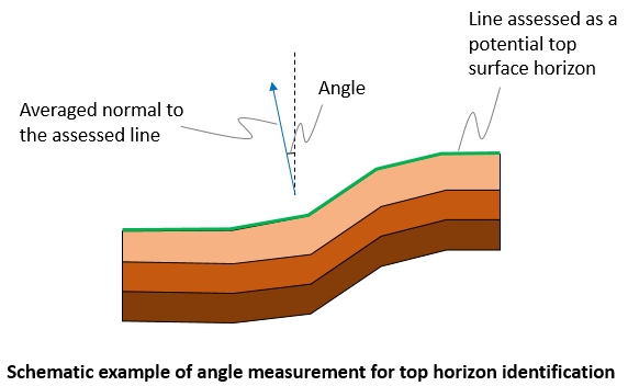
The top surface horizon is automatically evaluated. Top_horizon_tolerance keyword may be used to set the maximum angle between the averaged normal to a line and the vertical axis (default 25 Degrees). If the angle is larger than that specified in Top_horizon_tolerance the line is discarded as a potential line from the top surface horizon. In summary the top surface horizon is identified by: •1 - - Considering all lines in the top stratigraphy unit •2 - - Excluding any lines shared with other units •3 - - Checking the difference between the average line normal and the vertical axis
|

