Step04 Restoration


The data files for restoration simulation are in: Geol_002b\Case03\04_Restoration\Data and Geol_002b\Case03_coarse\04_Restoration\Data. Most of the files are identical to those in Case02. The key files with erosion-relevant differences discussed here are:


1.Geol_002b_Case03_rest.dat: main restoration datafile which includes two stages for the erosion and deposition of the eroded formation.


2.Geol_002b_Case03_RestSurf02.dat: datafile containing the definition of the additional restoration surface to account for the eroded formation (Geol_002b_Case03_RestSurf01 is identical to the restoration surface of previous cases).


Main Restoration datafile


The present case comprises 13 stages with the sequence being as follows:


1.Geostatic stage to assign the initial porosities, facies distribution and assign couple freedoms on boundary nodes

2.Translate of formation10 (restoring the deposition of formation10)

3.Removal of formation10 and translate of formation09 (restoring the deposition of formation09)

4.Removal of formation09 and translate of formation08 (restoring the deposition of formation08)

5.Removal of formation08 and translate of formation07 (restoring the erosion of the eroded formation)

6.Translate of formation07 to the base of the eroded formation (restoring the deposition of the eroded formation)

7.Translate of formation07 to the "standard" restoration datum (restoring the deposition of formation07)

8.Removal of formation07 and translate of formation06 (restoring the deposition of formation06)

9.Removal of formation06 and translate of formation05 (restoring the deposition of formation05)

10.Removal of formation05 and translate of formation04 (restoring the deposition of formation04)

11.Removal of formation04 and translate of formation03 (restoring the deposition of formation03)

12.Removal of formation03 and translate of formation02 (restoring the deposition of formation02)

13.Removal of formation02 and translate of formation01 (restoring the deposition of formation01)


The data required to account for erosion and deposition of the eroded formation in restoration is shown below. Note that in order to maximize consistency between restoration and forward simulation the decompaction options need to be changed in the stages corresponding to the deposition and erosion of the eroded formation. This will be discussed below. Note that only minimal data is shown to demonstrate the sequence of stages and the restoration options in each one.


Data File


! Geostatic stage

* Restoration_data

! ---------------------------------

 Operation_type                         "None"


* Control_data

! ---------------------------------

 Control_title             "Geostatic"


! 1st restoration stage with translate/flattening of the top surface to the restoration surface

* Restoration_data

! ---------------------------------

 Operation_type                    "Translate"

 Decompaction_Type                 "Top_layer"


* Control_data

! ---------------------------------

 Control_title             "formation10"


! Restoration stages with removal of the top formation and translate/flattening of the next one

* Restoration_data

! ---------------------------------

 Operation_type                    "Restore"

 Decompaction_Type                 "Top_layer"


* Control_data

! ---------------------------------

 Control_title             "formation09"


* Control_data

! ---------------------------------

 Control_title             "formation08"


! Restoration stage corresponding to the erosion of the eroded formation.

* Restoration_data

! ---------------------------------

 Operation_type                   "Restore"

 Decompaction_Type                "Continuous"


* Control_data

! ---------------------------------

 Control_title             "Erosion"


! Restoration stage corresponding to the deposition of the eroded formation (creation of the accommodation space).

* Include

! ---------------------------------

 Filename  "Geol_002b_Case03_RestSurf02.dat"


* Restoration_data

! ---------------------------------

 Operation_type                    "Translate"

 Decompaction_Type                      "None"


* Control_data

! ---------------------------------

 Control_title             "Eroded_fm"


! Restoration stage corresponding to the deposition of the formation07.

* Include

! ---------------------------------

 Filename  "Geol_002b_Case03_RestSurf01.dat"


* Restoration_data

! ---------------------------------

 Operation_type                    "Translate"

 Decompaction_Type                 "Top_layer"


* Control_data

! ---------------------------------

 Control_title             "formation07"


! Restoration stage corresponding to the deposition of the formation06 and subsequent ones.

* Restoration_data

! ---------------------------------

 Operation_type                      "Restore"

 Decompaction_Type                 "Top_layer"


* Control_data

! ---------------------------------

 Control_title             "formation06"


* Control_data

! ---------------------------------

 Control_title             "formation05"


   (...)


The eroded formation is placed between formation07 and formation08. Consequently the data for stages up to flattening of formation08 is essentially the same as a restoration without considering any eroded formation.


During stage 5 (restoration/reversal of the erosion) the Operation_type is kept as "Restore" and the Decompaction_type is changed to "Continuous". In this stage the eroded formation (which is not explicitly in the domain) is conceptually exposed to erosion by being located above the restoration surface (which in the forward model can be considered as the sedimentation/erosion datum). Thus the top formation (formation08) is removed and the formation below the (non-explicitly represented) eroded formation is flattened / translated to the restoration surface. Because conceptually the eroded formation would be above the formation07 (current top formation in the geometry) the decompaction type "Top_layer" should not be used in this stage.


During stage 6 the aim is to reverse the deposition of the eroded formation. In order to do that the file "Geol_002b_Case03_RestSurf02.dat" containing the restoration surface defined consistent with the base of the eroded formation is loaded using the data structure Include. Such restoration surface is defined as the original flat restoration surface minus the thickness of the eroded formation at each location. Consequently the top of formation07 will be translated to the base of the eroded formation. The Decompaction_type is set as "None" as conceptually the eroded formation is above formation07 and from the previous stage the sediments below it already follow the respective normal compaction trends.


During stage 7 the aim is to reverse deposition of formation07. The restoration surface is overwritten again to the original flat restoration surface by reloading the "Geol_002b_Case03_RestSurf01.dat" file. The Operation_type is set to "Translate" so that the top of formation07 is translated to the restoration surface and the Decompaction_type is set as "Top_layer" so that the formations below formation0'7 are decompacted following the respective normal compaction trends.


During stage 8 the Operation_type is set to "Restore" so that formation07 is removed, formation06 is flattened to the restoration surafce and the restoration simulation proceeds as usual from this point onwards.


Erosion restoration surface


During stage 6 the restoration surface is changed to coincide with the base of the eroded formation. The definition of such restoration surface is within the file "Geol_002b_Case03_RestSurf02.dat". The data is shown below. Note that after such stage the original flat restoration surface is re-loaded back.


Data File


* Part_geometry_set         NUM=1

! ---------------------------------

 Name    "Restoration_surface"

 Part_surfaces   IDM=1

   1

 Part_lines  IDM=13

   1  2  3  4  5  6  7  8  9  10

  11 12 13          


* Part_surface  NUM=1

! ---------------------------------

 Facets   IDM=3 JDM=6

  1   5   6

  1   6   2

  2   6   7

  2   7   3

  3   7   8

  3   8   4

 Part_lines  IDM=13

   1  2  3  4  5  6  7  8  9  10

  11 12 13        


* Part_line  NUM=1

! ---------------------------------

 Facets   IDM=2 JDM=1

   1  2        


* Part_line  NUM=2

! ---------------------------------

 Facets   IDM=2 JDM=1

   2  3


  (...)


* Part_line  NUM=13

! ---------------------------------

 Facets   IDM=2 JDM=1

   3  8


* Part_nodal_data  NUM=1

! ---------------------------------

 Nodes   IDM=8

   1  2  3  4  5  6  7  8

 Coordinates  IDM=3  JDM=8

   30000   60000   8700

   45000   60000   8700

   55000   60000   8300

   83000   60000   8300        

   30000   85000   8700

   45000   85000   8700

   55000   85000   8300

   83000   85000   8300


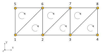
The restoration surface defining the base of the eroded sediment is composed of 3 flat surfaces connected at the edges in this case. Consequently requires the definition of a minimum of 8 nodes, 13 lines and 6 facets.


Note that the facets should be defined with 3 nodes ordered in clockwise direction with the restoration surface viewed from above. In such a way the facet normal points downwards towards the model geometry.


Geol_002b_Case03_Fig03

Schematic of the node numbering and the facet direction for the definition of the restoration surface. The figure shows the restoration surface viewed from above.


Results


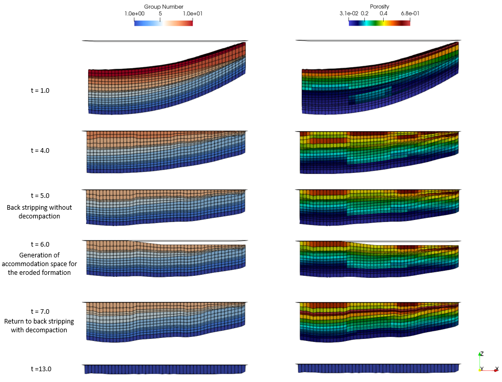
The results for the present workflow steps are provided in Geol_002b\Case03\04_Restoration\Results. Note that only a selection of the results is provided. In the figure below the results for the coarse mesh (for the sake of clarity in the figure)  models is shown. It can be seen how at time 6.0 the restoration generates the accommodation space for the eroded formation and the resulting basal displacements will be output in the spatial grid within the Geol_002b_Case03_rest_Disp_Eroded_fm.spat file.


Geol_002b_Case03_Fig04

Restoration results from the coarse mesh version