During this workflow step Zmap data will be read and imported to export an Abaqus format .inp file containing the HEX mesh. Then from this exported file the geometry will be created in the subsequent workflow step.
The data files for the Zmap import operation for the current example are in: Geol_003\Case01\Step01_Zmap_import\Data. It should be noted that the data is identical to the one in Geol_002b Case02 except the zmap import datafile "Geol_003_Case01_Step01_Zmap.dat" which selects to import a different sub-grid. The folder hence contains:
•Geol_003_Case01_Step01_Zmap.dat : Main data file to perform the Zmap import and generate a .inp file
A sub-folder named "Zmaps" which contains the following Zmap data files:
•FormationN.dat : Zmap file containing the Z coordinates for formation N.
•FormationN_actnum.dat : Zmap file containing the Active_flag property for formation N. Such property defines whether a cell is active or not for importing purposes (alternative method to defining null values in the Z coordinates for inactive cells).
•FormationN_Facies.dat : Zmap file containing the facies ID number for each cell of the formation N.
Data
The Util_eclipse_import data structure is used to define the importing and exporting format of the mesh/geometry as well as sub-grid to be imported, cell subdivision options, pinchout parameters for thin elements, the cell properties to be imported from Zmap data and any other conversion options.
Data File
|
|
* Util_eclipse_import
Input_file_type "Zmap"
Output_coordinate_type "None"
Output_file_type "Abaqus"
Output_file_name "Geol_003_Case01_Step01_abaq"
Stratigraphy_flag 1
Pinchout_properties IDM=2
100
102
Pinchout_direction 2
Property_names IDM=2
"Facies"
"Active_flag"
Sub_grid_dimensions IDM=6
60 46 1
64 52 10
Group_names IDM=10
formation10
formation09
...
formation01
Boundary_set_flag 2
Grid_subdivision_i 1
Grid_subdivision_j 1
Active_cell_property "Active_flag"
Spatial_grid_name Geol_003_Case01_Step01
Spatial_grid_type Group
Output_property_names IDM=1
"Facies"
|
•Input_file_type , Output_coordinate_type and Output_file_type are defined according to a Zmap --> Abaqus import. The Abaqus formatted HEX mesh will be exported to a file named "Geol_003_Case01_Step01_abaq.inp" as indicated in the Output_file_name keyword.
•Stratigraphy_flag must be set to 1 in order to export all stratigraphy horizons (which will be required to perform the restoration).
•Pinchout_properties and Pinchout_direction define a criteria including the thickness tolerance to pinchout thin elements from the imported grid. This is often used to guarantee that the converted geometry does not have thin elements which may lead to numerical issues.
•Property_names keyword is used to define all the properties that will be read / imported from Zmap data. Note that each property listed here will require definition of its Util_zmap_import data structure (in addition to the one used to import the Z coordinates). In the present case "Facies" and "Active_flag" properties are going to be imported from Zmap data.
•Sub_grid_dimensions is used to select the sub-grid imported from the whole Zmap model by defining the I, J, K cell bounds of the sub-grid. In the present case a regular sub-grid is selected (i.e. with non-ragged boundaries as required for the TET meshes workflow)
•Within Group_names keyword the list of imported group names is defined from top to bottom.
•Boundary_set_flag must be set to 2 for the present workflow in order to export all model boundaries.
•Grid_subdivision_i and Grid_subdivision_j are both set to 1 (no subdivision in X and Y directions) and because Grid_subdivision_list_k is not specified there will be no subdivisions in the Z direction neither. This is set for the sake of obtaining a HEX mesh with the minimum cells possible (note that the target mesh will be a TET mesh)
•Spatial_grid_name, Spatial_grid_type and Output_property_names keywords are used to request the output of the .spat file containing a Spatial_grid with the Facies number for each cell. Note that the Spatial_grid_type must be set to "Group" for the present workflow (note that the obtained HEX grid will be used to map its values to a TET mesh).
•Note that any other property imported via an Util_zmap_import data structure may be output as a Spatial_grid by listing it within the Output_property_names keyword. The different properties will be output in separate .spat files which will be named according to the name defined in Spatial_grid_name with the property name appended (i.e. in this case the code will output a file named "Geol_003_Case01_Step01_Facies.spat") |
Data File
|
|
* Util_zmap_import NUM=1
Operation_type "Geometry"
File_names IDM=11
Zmaps\formation10.dat
Zmaps\formation09.dat
(...)
Zmaps\base.dat
* Util_zmap_import NUM=2
Operation_type "Property"
Property_name "Facies"
Property_type "Int"
File_names IDM=11
Zmaps\formation10_Facies.dat
Zmaps\formation09_Facies.dat
(...)
Zmaps\formation01_Facies.dat
* Util_zmap_import NUM=3
Operation_type "Property"
Property_name "Active_flag"
Property_type "Int"
Processing_flag 1
File_names IDM=11
Zmaps\formation10_actnum.dat
Zmaps\formation09_actnum.dat
(...)
Zmaps\base_actnum.dat
|
•Three Util_zmap_import data structures are defined to import the three types of Zmap data considered in the present case; one for the Z coordinates defining the geometry and two for the properties imported from Zmap data previously defined in Property_names keyword within Util_eclipse_import.
•Note that as the Zmap data files are placed in the Zmaps sub-folder the appropriate paths are defined in File_names.
•For the imported properties Operation_type is set to "Property", the respective imported property names are defined using Property_name keyword and each property type is defined using Property_type (in this case both are internal properties as those are properties that are directly used by ParaGeo, other not internal properties could be imported for visualisation/tracking purposes)
•Note that the last Util_zmap_import requires definition of the Processing_flag 1 keyword in order to specify that no extra Zmap data will be imported. |
|
Results
The results for the present workflow steps are provided in Geol_003\Case01\Step01_Zmap_import\Results
After Zmap import two key files are ouput:
1.Geol_003_Case01_Step01_abaq.inp file containing the mesh in Abaqus format. This will be run by ParaGeo on the next workflow step in order to obtain the .geo file 2.Geol_003_Case01_Step01_Facies.spat containing a Spatial_grid with a Spatial_grid_group format containing the Facies distribution.
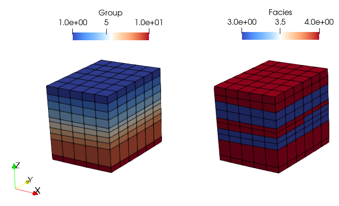
The considered subgrid and the distribution of the imported Facies may be visualised by loading the file Geol_003_Case01_Step01_Zmap_update_eclipse.xmf in ParaView.

View of the Group and Facies numbers for the imported sub-grid. Note that the group numbering in Zmap import starts from top to bottom but this will be edited in a later workflow step.
|

