Case 1 Base Case with Extension only
This base case bench scale example aims to capture the formation of a single salt diapir penetrating through the overburden to the top in an extensional loading sequence. A full description of the data required for this base case is presented here. Subsequent cases will only contain description of key data different from this base case.
| Problem Description |
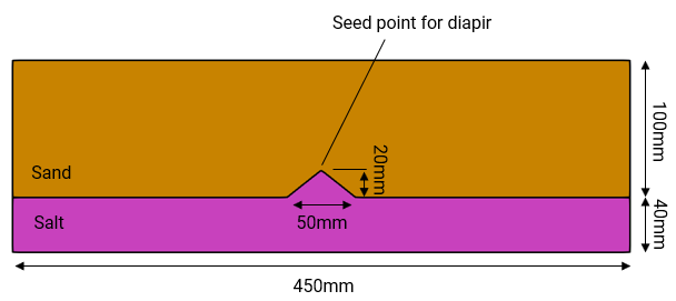
The problem consists of a 450mm long by 40mm high salt sample with 100mm high sand overburden that is subjected to extension of the side boundaries via an applied displacement in X. A seed point is located at the centre of the salt horizon to promote diapir formation. An initial stage is performed where gravity is activated using a linear ramp curve prior to initiating the extensional phase in stage 2.
Units of the model for stress, length and time are Pa, mm and years respectively. The simulation run completes in 3 mins on a 3.6 GHz AMD processor machine.
|
The simulation comprises two stages with the timings summarized in the table below :
Stage # |
Description |
Stage duration (hours) |
Time lapse (hours) |
Stage 1 |
Geostatic initialization with gravity |
0.5 |
0 - 0.5 |
Stage 2 |
Extensional loading of side boundaries at 25mm/hr |
1.8 |
0.5 - 2.3 |
| Basic Set Up: Data File Description |
The data file for the project is in : Mech_005\Case01\Data. The basic data for Case 1 includes:
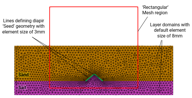
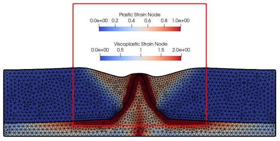
1Units defining stress in "Pa", length in "mm", time in "hrs" and temperature in "Celsius". Note that temperature units is required to be defined but is not used in the simulation. 2Mesh_parameter_data defining system settings for mesh generation with small perturbation to give a less regular mesh. 3Geometry_set data defining model boundaries and stratigraphy horizons. 4Group_control_data activates the geomechanical field for the pre-existing groups and Group_data defines the name, element type, material name, porous flow type and geometry associated with the group. 5Stratigraphy_definition and Stratigraphy_horizon defining stratigraphy data for the pre-existing layers. Note that if there are stability issues of the top surface, Stratigraphy_surface_load data with a small value for Applied_stress can be defined for the top surface. However, there is no requirement in this example. 6Material_data to read in the "Salt" and "Sand_1" material properties contained in the external material file "Mech_005.mat" which defines the material properties of the pre-existing layers. 7Support data (Support_data) defining base fixed vertically and sides constrained horizontally. The side geometries are prescribed extensional displacements in X in stage2 using Global_loads, Time_curve_data and Load_case_control_data. 8Gravity data (Gravity_data) applied with "Step_ramp" time curve. 9Data required to define geostatic initialization (Geostatic_data) using a "Step_ramp" time curve with K-values of 0.6 for Sand and 1.0 for Salt. 10Mesh control (Mesh_control_data) and unstructured mesh generation data (Unstructured_mesh_data) defining a constant mesh size of 8mm for the layer domains and smaller mesh size of 3mm for the seed geometry lines. A perturbation of 0.05 is defined for the mesh generation to give a less regular mesh (Mesh_parameter_data). 11Adaptivity control (Adaptivity_control_data) and adaptivity set data (Adaptivity_set_data) specifying a remesh check every 100 steps with remeshing triggered at a distortion of 10%. Adaptive mesh refinements with target elements sizes are controlled by the combined use of Coarsening_data based on plastic strain (Sand) and viscoplastic strain (Salt) and the use of Rate_error_data based on the normalised plastic strain rate (Sand) and normalised viscoplastic strain rate (Salt). 12Control data (Control_data) defining the usage of the transient solution algorithm (Type 1), duration, factor of critical time step, output frequency data, etc. 13Geometry data (Nodal_data, Geometry_line and Geometry_surface) for definition of the pre-existing layer geometries.
Following are descriptions of some key data. Note that these data descriptions are not in the same order as they appear in the data file.
|
The result files for the project are in directory: Mech_005\Case01\Results.
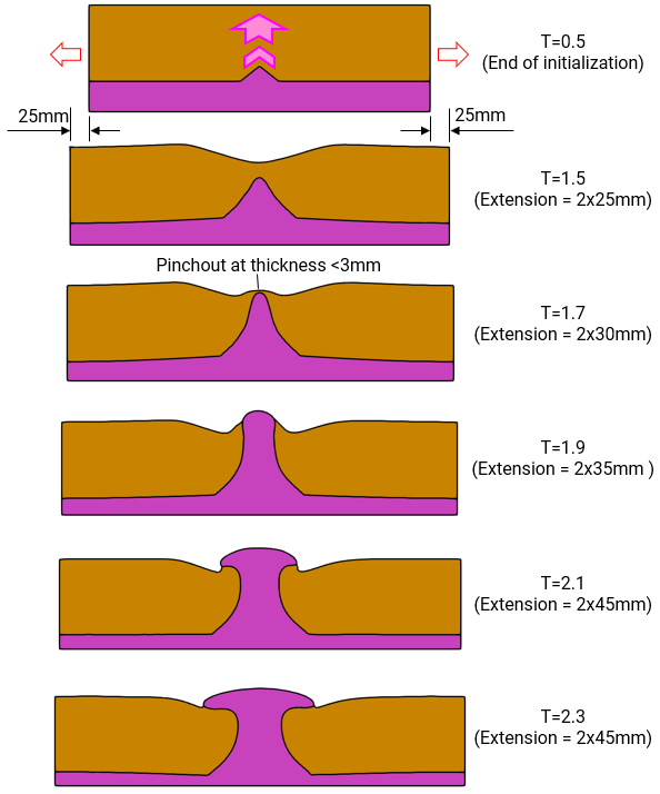
The figures below show the formation of the salt diapir through a buoyancy driven ascent of salt under extensional settings. Note that for this example, the bulk density of the salt material is 960.3 kg/m3 (with grain density of 970 kg/m3 and porosity of 0.01) and the bulk density of the sand material is 1761.5 kg/m3 (with grain density of 2710 kg/m3 and porosity of 0.35).
Formation of Salt Diapir through Time
|


