HM_005 Case1 8% shortening at strain rate of 0.16/Ma
In this example a deposition of 4000 m of sediment followed by 8% of shortening at a strain rate of 0.16/Ma (16% of strain per million years) will be simulated. The deposition will be performed in 10 layers of 400 m height each. The column width is 1000m so that the applied tectonic displacement will be 80m. In order to apply 8% of shortening at 0.16/Ma strain rate the complete displacement should last 0.5 Ma. A detailed description of the deposition data file and restart data file with the tectonic event are shown below.
First the depositional stage should be run, and subsequently the restart data file can be executed.
The initial data file for the project is: HM_005\Data\hm_005_Case1.dat. The basic data includes: 1Units defining stress in "MPa", length in "m", time in "Ma" and temperature in "Celsius". 2Geometry_set data defining model boundaries. 3Group_control_data activates the geomechanical and porous fields for the pre-existing group and Group_data defines the name, element type, material name, porous flow type and geometry associated with the group. 4Stratigraphy_definition and Stratigraphy_horizon defining stratigraphy data for the pre-existing layer. 5Stratigraphy_surface_load to prescribe conditions at the surface: (a) A small mechanical load (0.2 MPa) at surface to avoid positive stresses (and material flow in larger geological models. This is applied with the ParaGeo inbuilt "Step-ramp" curve which is a linear ramp curve. (b) A prescribed pore pressure of 0 MPa by setting Pore_pressure_flag = 1. 6Material_data to read in the "clay" material properties and the Fluid_properties contained in the external material file "clay_CF040.mat" which defines the material properties of the pre-existing and all sedimentation layers. 7Damping_global_data defining the use of combined damping models (mass proportional damping of 2% and bulk viscosity damping with constant of 0.5). 8Support data (Support_data) defining: (a) Geomechanical field: Base fixed vertically and sides fixed horizontally. 9Gravity data (Gravity_data) applied with "Step_ramp" time curve. 10Mesh control (Mesh_control_data) and structured mesh generation data (Structured_mesh_data, Structured_line_set) defining a uniform mesh with 10 x 1 elements per layer. 11Adaptivity control (Adaptivity_control_data) and adaptivity set data (Adaptivity_set_data) specifying a remeshing check set as a very large number 5E8 (to avoid remeshing). Note that the element size data here are not used - the number of structured divisions for the new sedimented layers are defined in the Sedimentation_parameters. 12Sedimentation_parameters and Sedimentation_data defining the sedimentation data for the new layers. 13Coupling data (Couple_control_data) to define an incremental coupling between the geomechanical and fluid flow fields using the fixed stress volume strain update algorithm. The coupling algorithm is set to "Fixed_stress" as the deposited material is not overly low perm and there is a direct pathway for the pore pressure to dissipate from the top surface over the simulated time frame. 14Porous_flow_control_data defining the data specific to the porous flow solution control with solution algorithm defined as nonlinear transient. 15Control_data for the initial and all sedimentation stages except final sedimentation stage defining: (a) Incremental transient solution algorithm (Type 4). (b) Duration of 4.0 Ma. (c) Flow time increment of 0.04 (i.e. coupling time step of 0.04Ma, therefore 100 coupling times for stage duration of 4.0Ma). (d) Target number of mechanical steps per coupling step set to 200, therefore total of 200*100=20,000 mechanical steps for stage duration of 4.0Ma. (e) Plot file every 1.0 Ma (i.e. four plotfiles per stage). (f) Screen message output every 10 flow increments. (g) Output_frequency_restart set to -1 indicating that a new restart file at the end of that stage will be created. The restart file name is "model_name_stage_number.rst" 16In the final sedimentation stage, the control data includes three additional time step data (Maximum_time_increment, End_step_time_increment, Transient_time_step_growth) to allow a gradual reduction of the time step increments to be compatible with the initial time step of the next stage (i.e. tectonic stage). This is in order to prevent a sudden change of time step increment at the start of the next stage. 17Geometry data (Nodal_data, Geometry_line and Geometry_surface) for definition of the pre-existing layer geometry (1000m x 400m column).
|
The Restart data file for the project is: HM_005\Case1\Data\Restart_hm_005_Case1_Tectonic.dat. The basic data includes: 1Restart_read_data to specify the restart file that will be read. 2Global_loads data structure to define a prescribed displacement of -80 m (8% of shortening) on the right hand boundary defined by the Geometry_set named "East". 3Time_curve_data that defines the time curve for the tectonic event, i.e. linear ramp over a time duration of 0.5 Ma. 4Load_case_control_data to define the Global_load associated with the tectonic event as active. 5Couple control (Couple_control_data) and control data (Control_data). The coupling algorithm is changed from "Fixed_stress" to "Undrained" as the tectonic shortening loading applied here can be considered a relatively large strain (16% strain) applied over a short time period (1Ma). As such the pore pressure would not have time to dissipate from the top surface and we would expect overpressure to develop significantly at the base where the perm is low. 6Control_data for the tectonic stage defining: (a) Incremental transient solution algorithm (Type 4). (b) Duration of 0.5 Ma. (c) Flow time increment of 0.002 (i.e. coupling time step of 0.002 Ma, therefore 250 coupling times for stage duration of 0.5 Ma). (d) Target number of mechanical steps per coupling step set to 200, therefore total of 200*250=50,000 mechanical steps for stage duration of 0.5 Ma. (e) Plot file every 0.1 Ma (i.e. five plot files).
|
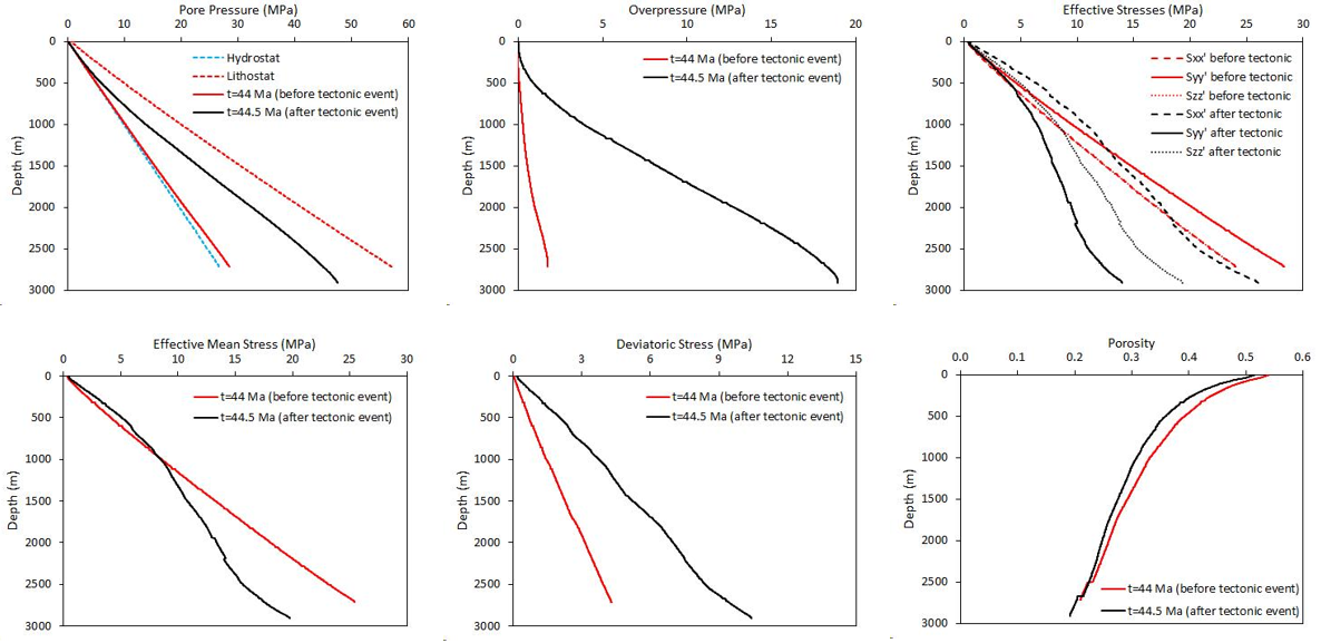
The result files for the project are in directory: HM_005\Case1\Results. This directory also contains the excel file 00_hm_005_Case01.xlsx which contains ParaView plot over line results at time 44 Ma and 44.5 Ma as shown graphically below.
The effects of the tectonic event can be visualized below: - increase in overpressure, - decrease in porosity, - increase in Sxx', decrease in Syy' and Szz', - increase in deviatoric stress, increase in effective mean stress at depths above 1285 m and decrease in effective mean stress at depths below 1285m.
Parameters vs depth before and after the tectonic event
|

